The MAP-M4 Mapping Quadcopter
The MAP-M4 multirotor survey copter set is built primarily for surveying and mapping with the Structure from Motion (SfM) technique. To ensure viable image acquisition operations anywhere in the world, the MAP-M4 copter design features the following characteristics:
- PPK GNSS equipped. Ready for highly efficient geo-referenced mapping anywhere in the world. 20Hz dual frequency GNSS phase observations and camera exposure event marking make of the MAP-M4 a formidable tool to complement conventional survey instrumentation.
- Locally repairable. The MAP-M4 is built mostly from off the shelf components and can thus be repaired in or near the operational area. There is no need to ship the equipment to the manufacturer for maintenance or repairs and, except for a few select items, there are no parts that are exclusively supplied by the vendor. Custom parts are available from Micro Aerial Projects for all registered owners of MAP-M4 copters.
- The MAP-M4 was designed by surveyors for surveyors. The design is based on an understanding of the business of surveying. Keeping the replacement costs of the airborne component of the MAP-M4 system at affordable levels ensures that operational risks are manageable.
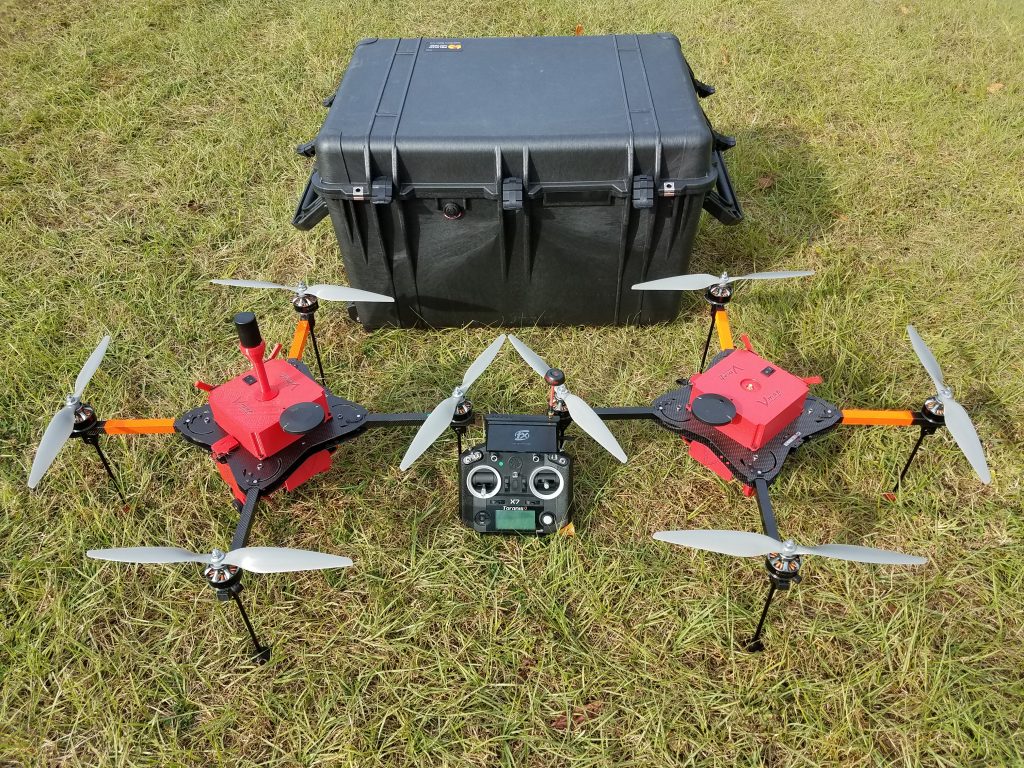
- One is none – two is one. Because of its extraordinary affordability, the MAP-M4 package includes TWO fully assembled, fully operational platforms. Nothing is worse than experiencing loss of production due to operator or equipment failure. Having two platforms in your toolbox reduces the risk of production loss by 50%. Of course, if you prefer to have only one unit, we offer a single unit too!
- Safe and reliable. At the heart of the MAP-M4 platform is an open source flight controller, the famous CUBE which is the most widely tested and supported flight controller used by thousands of surveyors and mappers all over the world. To ensure safety and mitigate human error, MAP-M4 platforms are configured and tuned for automatic aerial image acquisition missions. To provide for adaptability in safety measures for job specific conditions, a choice of easily installed fail safe measures form part of the system configuration. There are no proprietary boundaries standing in the way of a MAP-M4 owner! For redundancy the Map-M4 platform is powered by two flight batteries.
- World Wide Support. The international user base of the open source Ardupilot flight code and CUBE flight controller with associated ground control software, Mission Planner, is one of the world’s largest group of experts in drone operations. Their experience and skills are an enormous source of support for drone surveyors anywhere in the world.
- Flick of the Switch Mapping. The MAP-M4 is a surveyor's drone. If you follow the operations guide and use the check-list you will hardly ever have to manually control the MAP-M4. Unless unforeseen traffic is encountered in the operational air-space, all MAP-M4 image acquisition flights are initiated with the flick of a switch and end with a fully automatic landing. Should the need arise to steer the platform manually, the controls have been configured in such a way that MAP-M4 is easily and intuitively controllable manually even by inexperienced operators.
Download MAP-M4 Technical Specifications / Download MAP-M4 Options & Pricelist


0%

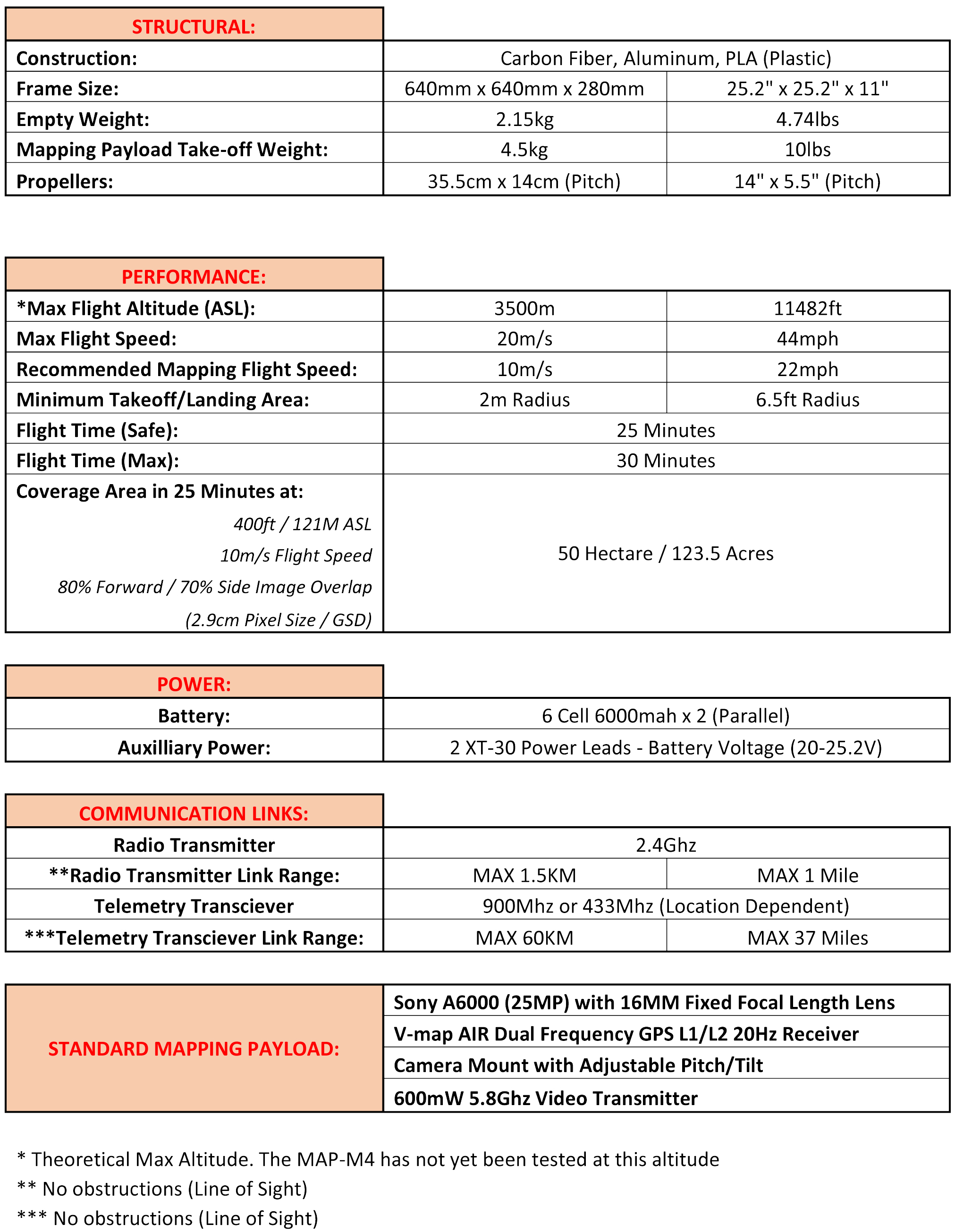
MAP-M4 Technical Specifications
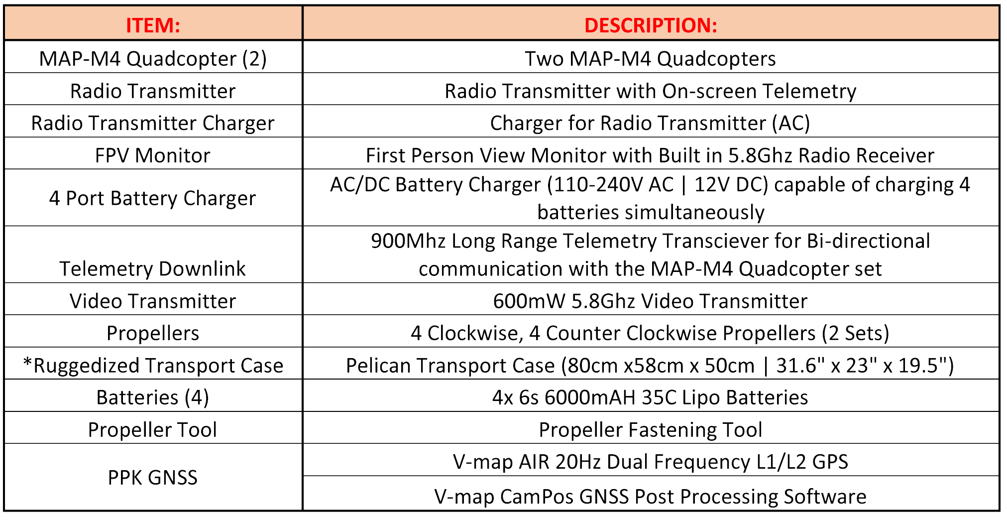
What’s included in the MAP-M4 Mapping Package: