
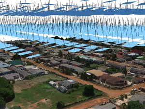
UAV Surveying & Mapping
Taking decades of experience in surveying into the UAS industry, we work with a variety of UAV platforms and our V-Map system to produce high resolution aerial photography, orthoimagery, highly accurate and detailed topographic data and high resolution maps and models for a variety of applications.
LEARN MORE
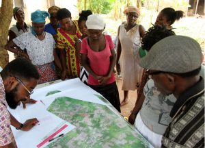
Resettlement Action Plans
With experience in many countries on six of seven continents, Micro Aerial Projects is well positioned to help you efficiently and cost-effectively address your development needs around the world. With our V-Map system on-board small, portable and field repairable UAVs, we can carry out on-demand high accuracy surveying and mapping tasks and create 3D models of villages and cities, buildings, infrastructure and the land as well as detailed inspections. This information is vital in determining property rights and land ownership as well as in resettlement action plans.
LEARN MORE
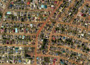
Cadastral Surveying
We are always on the look-out for more efficient and affordable techniques in cadastral surveying. Having pioneered the use and implementation of GPS in cadastral surveying in the early 1990s, we know how important it is to convince policy makers by way of scientific and robust error analyses whether a technique or method is appropriate and whether it meets minimum standards in geodetic and cadastral survey settings. Today our focus is on the use of drones to acquire aerial imagery and the application of the Structure from Motion (SfM) technique to generate geo-spatial products which drastically improve the efficiency in cadastral surveying.
LEARN MORE

Construction Site Monitoring
Micro Aerial Projects uses small UAVs and the V-Map System to help you cost effectively monitor all phases of your construction activities from site preparation through to project completion. Easy to manage, portable and flexible in their ability to get quickly to otherwise difficult areas of access, our unmanned aerial vehicles (UAVs) can safely and immediately transmit high resolution photographs and videos to the construction management team.
LEARN MORE
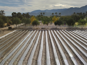
Agriculture & Environmental Monitoring
Small UAVs offer a timely and cost effective means of collecting high resolution data of particular use to agricultural and environmental assessment and monitoring. A combination of the ability to fly safely at a lower altitude, flexibility and maneuverability means that inspections can be conducted in areas which can be difficult or hazardous to access by other methods and allows for greater coverage than conventional approaches.
LEARN MORE
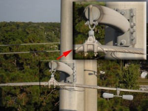
Infrastructure & Industrial Inspections
Using small, portable, highly maneuverable and field repairable platforms with our V-Map system enables us at Micro Aerial Projects to safely assist you inspect and monitor your energy, transportation, communication and structural infrastructures. Inspections can be done quickly and on demand with live, precise, high resolution imagery transmitted immediately for on and offsite assessment and decision making. Critical and preventative monitoring of infrastructure stress can be carried out on a regular basis at great cost savings and protection to human life.
LEARN MORE
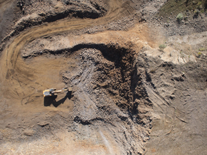
Mining & Volumetrics
The use of small unmanned aerial vehicles allows Micro Aerial Projects to capture highly accurate and actionable data efficiently and safely in the mining environment. The ability to capture this data without needing boots on the ground ensures that mining operations are not hindered and no unnecessary risks to the safety of surveyors are encountered.
LEARN MORE
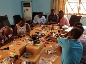
Training & Capacity Development
With our years of working with and on proprietary systems as well as building our own solutions, Micro Aerial Projects is fully capable of providing private and public institutions with capacity development courses. We offer drone assembly, tuning, and operating courses as well as courses on applications such as drone based mapping.
LEARN MORE
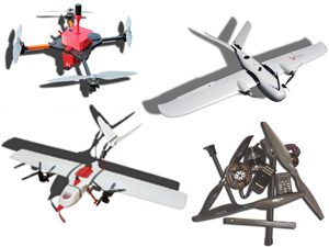
Unmanned Aerial Systems
From multi-rotors to fixed wings to hybrid VTOL platforms and custom builds for your application, Micro Aerial Projects offers safe, efficient and cost effective solutions for your aerial data collection needs.
LEARN MORE
Software
With a focus on price and functionality, we have a variety of software packages available including Structure from Motion (SfM), GIS and GNSS Post Processing Software available.
LEARN MORE
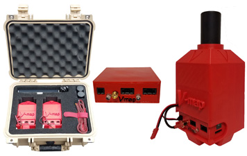
V-map GNSS
The V-map GNSS receivers were designed by surveyors for surveyors. The platform independent design allows for rapid installation on your UAS for Post Processed Kinematic (PPK) solutions for your camera exposures and can be used on a survey rod for conventional GNSS terrestrial surveys. Adding V-map to your UAS operation gives your organization more flexibility in precision surveying operations both in the air and on the ground.